Geological Map of Volcanoes 24
Geological map of Ontake Volcanoes
 | |
| Series | Geological Map of Volcanoes |
| No. | 24 |
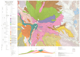
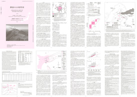
| Map Name | GEOLOGICAL MAP OF ONTAKE VOLCANO |
| Author | OIKAWA Teruki, TAKESHITA Yoshihiro, YAMASAKI Seiko |
| Publication year | 2025 |
| Scale | 1:25,000 |
| Publisher | Geological Survey of Japan, AIST |
| Price | ¥1,650 ( Purchase Guide ) |
| Prefecture | GIFU, NAGANO |
| Size | A1(841mm×594mm) |
| Downloads | Raster(JPEG, GeoTIFF) data, Vector data, Explanatory Text(PDF) |
 | |
| Series | Geological Map of Volcanoes |
| No. | 24 |
| Map Name | GEOLOGICAL MAP OF ONTAKE VOLCANO |
| Author | OIKAWA Teruki, TAKESHITA Yoshihiro, YAMASAKI Seiko |
| Publication year | 2025 |
| Scale | 1:25,000 |
| Publisher | Geological Survey of Japan, AIST |
| Price | ¥1,650 ( Purchase Guide ) |
| Prefecture | GIFU, NAGANO |
| Size | A1(841mm×594mm) |
| Downloads | Raster(JPEG, GeoTIFF) data, Vector data, Explanatory Text(PDF) |
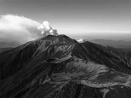 |
| View of Ontake volcano from the northern sky (about 8:30 on September 28, 2014). The depression in the foreground is the Yonnoike crater, and the lake behind it is Sannoike. The highest peak in front of the volcanic cloud is Kengamine Peak (3,067m). Volcanic clouds are rising from Jigokudani. |